Geolocate

Tonyrefail topographic map

Click on the map to display elevation.

About this map

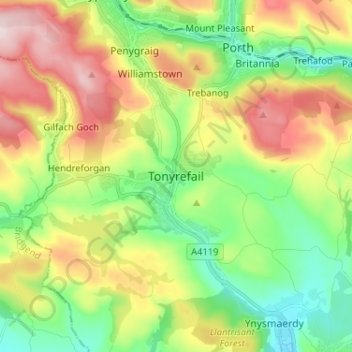
Name: Tonyrefail topographic map, elevation, terrain.

Location: Tonyrefail, Rhondda Cynon Taf, Wales, CF39 8AA, United Kingdom (51.54327 -3.47117 51.62327 -3.39117)

Average elevation: 206 m

Minimum elevation: 56 m

Maximum elevation: 433 m

Rhondda Cynon Taf trails, hiking, mountain biking, running and outdoor activities

Other topographic maps

Click on a map to view its topography, its elevation and its terrain.

Mid Glamorgan

United Kingdom > Wales > Rhondda Cynon Taf

Average elevation: 235 m

Pontypridd

United Kingdom > Wales > Rhondda Cynon Taf

Average elevation: 183 m

Penrhiwceiber

United Kingdom > Wales > Rhondda Cynon Taf

Average elevation: 229 m

Pontypridd

United Kingdom > Wales > Rhondda Cynon Taf

Average elevation: 183 m

Trealaw

United Kingdom > Wales > Rhondda Cynon Taf > Tonypandy

Average elevation: 222 m

Gear up for your next adventure:

🧥Waterproof Hiking Jackets - Rain protection for walking in all weather conditions
🧣Fleece Neck Warmers - Extra insulation for winter topographic surveys
🥫Expedition Meals - Lightweight, high-calorie nutrition for long-distance hikers
🥄Titanium Camping Sporks - The ultimate lightweight utensil for trail meals
🛑Emergency Bivvy Bags - Heat-reflective survival bags for unexpected nights out

As an Amazon Associate, this site earns from qualifying purchases at no extra cost to you.