
Make a donation
Gear up for your next adventure:
As an Amazon Associate, this site earns from qualifying purchases at no extra cost to you.
Huntington topographic map
Click on the map to display elevation.
Make a donation
Gear up for your next adventure:
As an Amazon Associate, this site earns from qualifying purchases at no extra cost to you.
About this map
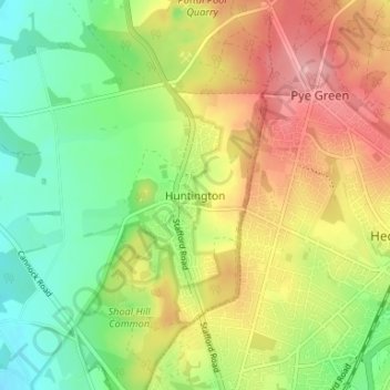
Name: Huntington topographic map, elevation, terrain.
Average elevation: 166 m
Minimum elevation: 107 m
Maximum elevation: 239 m
Staffordshire trails, hiking, mountain biking, running and outdoor activities
Make a donation
Gear up for your next adventure:
As an Amazon Associate, this site earns from qualifying purchases at no extra cost to you.
Other topographic maps
Click on a map to view its topography, its elevation and its terrain.
Weston Park
United Kingdom > England > Staffordshire > South Staffordshire > Weston under Lizard
Average elevation: 113 m
Himley
United Kingdom > England > Staffordshire > South Staffordshire > Himley
Average elevation: 118 m
Make a donation
Gear up for your next adventure:
As an Amazon Associate, this site earns from qualifying purchases at no extra cost to you.
Make a donation
Gear up for your next adventure:
As an Amazon Associate, this site earns from qualifying purchases at no extra cost to you.
Highgate Common
United Kingdom > England > Staffordshire > South Staffordshire > Enville
Average elevation: 92 m
Mottey Meadows NNR
United Kingdom > England > Staffordshire > South Staffordshire > Wheaton Aston
Average elevation: 110 m
Make a donation
Gear up for your next adventure:
As an Amazon Associate, this site earns from qualifying purchases at no extra cost to you.
Shareshill
United Kingdom > England > Staffordshire > South Staffordshire > Shareshill
Average elevation: 123 m
Baggeridge Country Park
United Kingdom > England > Staffordshire > South Staffordshire
Average elevation: 146 m
Make a donation
Gear up for your next adventure:
As an Amazon Associate, this site earns from qualifying purchases at no extra cost to you.
Wombourne
United Kingdom > England > Staffordshire > South Staffordshire > Wombourne
Average elevation: 112 m
Cannock Lake
United Kingdom > England > Staffordshire > South Staffordshire > Huntington
Average elevation: 149 m
Make a donation
Gear up for your next adventure:
As an Amazon Associate, this site earns from qualifying purchases at no extra cost to you.