
Make a donation
Gear up for your next adventure:
As an Amazon Associate, this site earns from qualifying purchases at no extra cost to you.
Penkridge topographic map
Click on the map to display elevation.
Make a donation
Gear up for your next adventure:
As an Amazon Associate, this site earns from qualifying purchases at no extra cost to you.
About this map
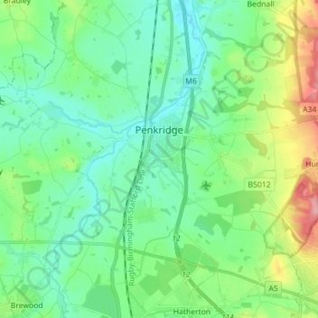
Name: Penkridge topographic map, elevation, terrain.
Average elevation: 106 m
Minimum elevation: 74 m
Maximum elevation: 197 m
Staffordshire trails, hiking, mountain biking, running and outdoor activities
Make a donation
Gear up for your next adventure:
As an Amazon Associate, this site earns from qualifying purchases at no extra cost to you.
Other topographic maps
Click on a map to view its topography, its elevation and its terrain.
Weston Park
United Kingdom > England > Staffordshire > South Staffordshire > Weston under Lizard
Average elevation: 113 m
Make a donation
Gear up for your next adventure:
As an Amazon Associate, this site earns from qualifying purchases at no extra cost to you.
Levedale
United Kingdom > England > Staffordshire > South Staffordshire > Penkridge
Average elevation: 98 m
Bednall
United Kingdom > England > Staffordshire > South Staffordshire > Bednall
Average elevation: 118 m
Make a donation
Gear up for your next adventure:
As an Amazon Associate, this site earns from qualifying purchases at no extra cost to you.
Halfpenny Green
United Kingdom > England > Staffordshire > South Staffordshire
Average elevation: 91 m
Calf Heath
United Kingdom > England > Staffordshire > South Staffordshire > Hatherton Junction
Average elevation: 113 m
Make a donation
Gear up for your next adventure:
As an Amazon Associate, this site earns from qualifying purchases at no extra cost to you.
Mottey Meadows NNR
United Kingdom > England > Staffordshire > South Staffordshire > Wheaton Aston
Average elevation: 110 m
Whiston
United Kingdom > England > Staffordshire > South Staffordshire > Penkridge
Average elevation: 95 m
Make a donation
Gear up for your next adventure:
As an Amazon Associate, this site earns from qualifying purchases at no extra cost to you.
Lutley
United Kingdom > England > Staffordshire > South Staffordshire > Enville
Average elevation: 100 m
Six Ashes
United Kingdom > England > Staffordshire > South Staffordshire > Bobbington
Average elevation: 125 m
Make a donation
Gear up for your next adventure:
As an Amazon Associate, this site earns from qualifying purchases at no extra cost to you.
Weston under Lizard
United Kingdom > England > Staffordshire > South Staffordshire
Average elevation: 111 m
Baggeridge Country Park
United Kingdom > England > Staffordshire > South Staffordshire
Average elevation: 146 m
Make a donation
Gear up for your next adventure:
As an Amazon Associate, this site earns from qualifying purchases at no extra cost to you.
Hatherton Junction
United Kingdom > England > Staffordshire > South Staffordshire
Average elevation: 112 m
Himley
United Kingdom > England > Staffordshire > South Staffordshire > Himley
Average elevation: 96 m
Make a donation
Gear up for your next adventure:
As an Amazon Associate, this site earns from qualifying purchases at no extra cost to you.
Cannock Lake
United Kingdom > England > Staffordshire > South Staffordshire > Huntington
Average elevation: 149 m
Make a donation
Gear up for your next adventure:
As an Amazon Associate, this site earns from qualifying purchases at no extra cost to you.
Gospelash
United Kingdom > England > Staffordshire > South Staffordshire > Bobbington
Average elevation: 91 m
Kinver Edge
United Kingdom > England > Staffordshire > South Staffordshire > Kinver
Average elevation: 95 m