
Pattingham topographic map
Click on the map to display elevation.
About this map
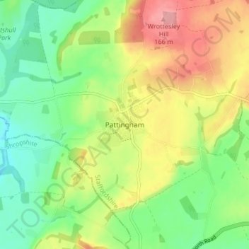
Name: Pattingham topographic map, elevation, terrain.
Average elevation: 106 m
Minimum elevation: 58 m
Maximum elevation: 173 m
Staffordshire trails, hiking, mountain biking, running and outdoor activities
Other topographic maps
Click on a map to view its topography, its elevation and its terrain.
Weston Park
United Kingdom > England > Staffordshire > South Staffordshire > Weston under Lizard
Average elevation: 113 m
Himley
United Kingdom > England > Staffordshire > South Staffordshire > Himley
Average elevation: 118 m
Highgate Common
United Kingdom > England > Staffordshire > South Staffordshire > Enville
Average elevation: 92 m
Mottey Meadows NNR
United Kingdom > England > Staffordshire > South Staffordshire > Wheaton Aston
Average elevation: 110 m
Shareshill
United Kingdom > England > Staffordshire > South Staffordshire > Shareshill
Average elevation: 123 m
Baggeridge Country Park
United Kingdom > England > Staffordshire > South Staffordshire
Average elevation: 146 m
Wombourne
United Kingdom > England > Staffordshire > South Staffordshire > Wombourne
Average elevation: 112 m
Cannock Lake
United Kingdom > England > Staffordshire > South Staffordshire > Huntington
Average elevation: 149 m