
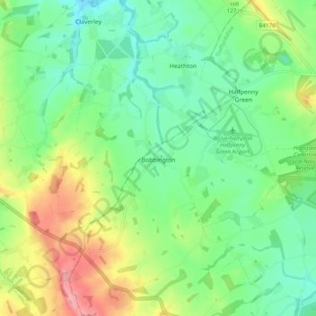
Bobbington topographic map
Interactive map
Click on the map to display elevation.
About this map
Name: Bobbington topographic map, elevation, terrain.
Average elevation: 98 m
Minimum elevation: 53 m
Maximum elevation: 186 m
Staffordshire trails, hiking, mountain biking, running and outdoor activities
Other topographic maps
Click on a map to view its topography, its elevation and its terrain.
Levedale
United Kingdom > England > Staffordshire > South Staffordshire > Penkridge
Average elevation: 98 m
Six Ashes
United Kingdom > England > Staffordshire > South Staffordshire > Bobbington
Average elevation: 125 m
Lutley
United Kingdom > England > Staffordshire > South Staffordshire > Enville
Average elevation: 100 m
Weston Park
United Kingdom > England > Staffordshire > South Staffordshire > Weston under Lizard
Average elevation: 113 m
Whiston
United Kingdom > England > Staffordshire > South Staffordshire > Penkridge
Average elevation: 95 m
Mottey Meadows NNR
United Kingdom > England > Staffordshire > South Staffordshire > Wheaton Aston
Average elevation: 110 m
Halfpenny Green
United Kingdom > England > Staffordshire > South Staffordshire
Average elevation: 91 m
Calf Heath
United Kingdom > England > Staffordshire > South Staffordshire > Hatherton Junction
Average elevation: 113 m
Gospelash
United Kingdom > England > Staffordshire > South Staffordshire > Bobbington
Average elevation: 91 m
Weston under Lizard
United Kingdom > England > Staffordshire > South Staffordshire
Average elevation: 110 m
Hatherton Junction
United Kingdom > England > Staffordshire > South Staffordshire
Average elevation: 112 m
Himley
United Kingdom > England > Staffordshire > South Staffordshire > Himley
Average elevation: 96 m
Cannock Lake
United Kingdom > England > Staffordshire > South Staffordshire > Huntington
Average elevation: 149 m
Bednall
United Kingdom > England > Staffordshire > South Staffordshire > Bednall
Average elevation: 118 m