
Nha Trang topographic map
Interactive map
Click on the map to display elevation.
About this map
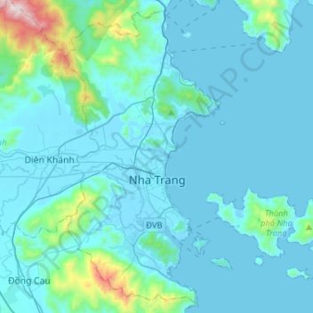
Name: Nha Trang topographic map, elevation, terrain.
Location: Nha Trang, Khánh Hòa Province, Vietnam (12.14288 109.11288 12.37991 109.37145)
Average elevation: 118 m
Minimum elevation: -2 m
Maximum elevation: 1,315 m
Other topographic maps
Click on a map to view its topography, its elevation and its terrain.
Sin Cowe East Island
Vietnam > Khanh Hoa province > Trường Sa District > Sinh Tồn Đông
Average elevation: 0 m
Central London Reef
Vietnam > Khanh Hoa province > Trường Sa District > Trường Sa
Average elevation: 0 m
Southwest Cay
Vietnam > Khanh Hoa province > Trường Sa District > Xã Song Tử Tây
Average elevation: 0 m