
Ampsin topographic map
Interactive map
Click on the map to display elevation.
About this map
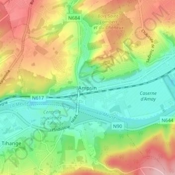
Name: Ampsin topographic map, elevation, terrain.
Location: Ampsin, Amay, Huy, Liège, Wallonie, 4540, Belgique (50.52024 5.26674 50.56024 5.30674)
Average elevation: 126 m
Minimum elevation: 54 m
Maximum elevation: 229 m
Other topographic maps
Click on a map to view its topography, its elevation and its terrain.