
Make a donation
Gear up for your next adventure:
As an Amazon Associate, this site earns from qualifying purchases at no extra cost to you.
Adamstown topographic map
Click on the map to display elevation.
Make a donation
Gear up for your next adventure:
As an Amazon Associate, this site earns from qualifying purchases at no extra cost to you.
About this map
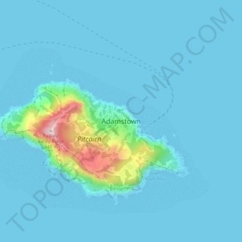
Name: Adamstown topographic map, elevation, terrain.
Location: Adamstown, Pitcairn Islands (-25.08667 -130.12021 -25.04667 -130.08021)
Average elevation: 29 m
Minimum elevation: -6 m
Maximum elevation: 326 m
Make a donation
Gear up for your next adventure:
As an Amazon Associate, this site earns from qualifying purchases at no extra cost to you.
Other topographic maps
Click on a map to view its topography, its elevation and its terrain.
Oeno Island
The main island (Oeno Island), about 50 hectares (120 acres) in area, has forest and scrub with pandanus and palm trees. It is located in the southwest part of the atoll's lagoon. There is a water tap installed on the island. The maximum elevation is less than 5 metres (16 ft). Sandy Island (or Islands) is to…
Average elevation: 0 m
Make a donation
Gear up for your next adventure:
As an Amazon Associate, this site earns from qualifying purchases at no extra cost to you.
Make a donation
Gear up for your next adventure:
As an Amazon Associate, this site earns from qualifying purchases at no extra cost to you.