
Make a donation
Gear up for your next adventure:
As an Amazon Associate, this site earns from qualifying purchases at no extra cost to you.
Pitcairn Island topographic map
Click on the map to display elevation.
Make a donation
Gear up for your next adventure:
As an Amazon Associate, this site earns from qualifying purchases at no extra cost to you.
About this map
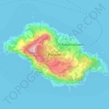
Name: Pitcairn Island topographic map, elevation, terrain.
Location: Pitcairn Island, Pitcairn Islands (-25.07972 -130.12299 -25.05955 -130.08774)
Average elevation: 45 m
Minimum elevation: -6 m
Maximum elevation: 326 m
Make a donation
Gear up for your next adventure:
As an Amazon Associate, this site earns from qualifying purchases at no extra cost to you.
Other topographic maps
Click on a map to view its topography, its elevation and its terrain.
Pawala Valley Ridge
Pawala Valley Ridge, is the highest point of the Pitcairn Islands, a British overseas territory in the southern Pacific Ocean, with an elevation of 347 metres (1,138 ft).
Average elevation: 56 m
Pawala Valley Ridge
Pawala Valley Ridge, is the highest point of the Pitcairn Islands, a British overseas territory in the southern Pacific Ocean, with an elevation of 347 metres (1,138 ft).
Average elevation: 56 m
Make a donation
Gear up for your next adventure:
As an Amazon Associate, this site earns from qualifying purchases at no extra cost to you.