Geolocate

Woolwich topographic map

Click on the map to display elevation.

About this map

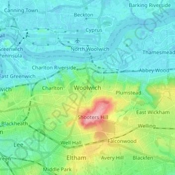
Name: Woolwich topographic map, elevation, terrain.

Location: Woolwich, Greater London, England, SE18 6FX, United Kingdom (51.44267 0.02233 51.52267 0.10233)

Average elevation: 28 m

Minimum elevation: -5 m

Maximum elevation: 130 m

England trails, hiking, mountain biking, running and outdoor activities

Gear up for your next adventure:

🕶️Glacier Goggles - Maximum protection for high-altitude snow topography
🛰️Handheld GPS Devices - Reliable GPS units for hiking and outdoor navigation
🔦LED Camping Lanterns - Illumination for reading maps inside your tent at night
🥾Walking Shoes - Lightweight walking shoes for countryside and coastal paths
🥄Titanium Camping Sporks - The ultimate lightweight utensil for trail meals

As an Amazon Associate, this site earns from qualifying purchases at no extra cost to you.