
Make a donation
Gear up for your next adventure:
As an Amazon Associate, this site earns from qualifying purchases at no extra cost to you.
La Gi topographic map
Click on the map to display elevation.
Make a donation
Gear up for your next adventure:
As an Amazon Associate, this site earns from qualifying purchases at no extra cost to you.
About this map
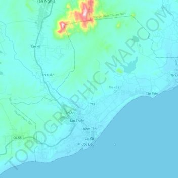
Name: La Gi topographic map, elevation, terrain.
Location: La Gi, Binh Thuan province, Vietnam (10.63104 107.68306 10.79676 107.88643)
Average elevation: 39 m
Minimum elevation: -1 m
Maximum elevation: 554 m
Make a donation
Gear up for your next adventure:
As an Amazon Associate, this site earns from qualifying purchases at no extra cost to you.
Other topographic maps
Click on a map to view its topography, its elevation and its terrain.
KDL MuiKeGa-BinhThuan
Vietnam > Binh Thuan province > Hàm Thuận Nam District > Văn Kê
Average elevation: 4 m
Make a donation
Gear up for your next adventure:
As an Amazon Associate, this site earns from qualifying purchases at no extra cost to you.