
Westenhanger topographic map
Interactive map
Click on the map to display elevation.
About this map
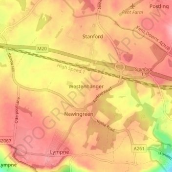
Name: Westenhanger topographic map, elevation, terrain.
Average elevation: 80 m
Minimum elevation: 4 m
Maximum elevation: 116 m
Kent trails, hiking, mountain biking, running and outdoor activities
Other topographic maps
Click on a map to view its topography, its elevation and its terrain.
Greatstone beach
United Kingdom > England > Kent > Folkestone and Hythe District > New Romney > Littlestone on Sea
Average elevation: 2 m
Elmsted
United Kingdom > England > Kent > Folkestone and Hythe District > Lymbridge Green
Average elevation: 144 m
Stelling Minnis
United Kingdom > England > Kent > Folkestone and Hythe District
Average elevation: 135 m
St. Mary in the Marsh
United Kingdom > England > Kent > Folkestone and Hythe District
Average elevation: 2 m