
Schenkenzell topographic map
Interactive map
Click on the map to display elevation.
About this map
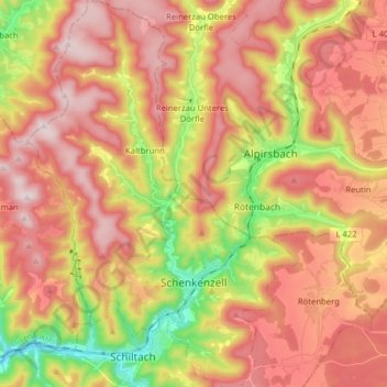
Name: Schenkenzell topographic map, elevation, terrain.
Average elevation: 603 m
Minimum elevation: 305 m
Maximum elevation: 828 m
Other topographic maps
Click on a map to view its topography, its elevation and its terrain.
Schiltach
Germany > Baden-Württemberg > Landkreis Rottweil
Schiltach, Verwaltungsgemeinschaft Schiltach, Landkreis Rottweil, Baden-Württemberg, 77761, Germany
Average elevation: 588 m
Oberndorf am Neckar
Germany > Baden-Württemberg > Landkreis Rottweil
Oberndorf am Neckar, Verwaltungsgemeinschaft Oberndorf am Neckar, Landkreis Rottweil, Baden-Württemberg, 78727, Germany
Average elevation: 615 m
Rottweil
Germany > Baden-Württemberg > Landkreis Rottweil
Rottweil, Verwaltungsgemeinschaft Rottweil, Landkreis Rottweil, Baden-Württemberg, 78628, Germany
Average elevation: 648 m
Schramberg
Germany > Baden-Württemberg > Landkreis Rottweil
Schramberg, Verwaltungsgemeinschaft Schramberg, Landkreis Rottweil, Baden-Württemberg, Germany
Average elevation: 706 m