Geolocate

Schiltach topographic map

Interactive map

Click on the map to display elevation.

About this map

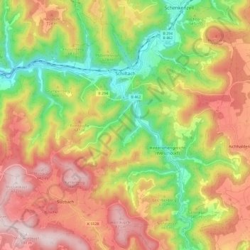
Name: Schiltach topographic map, elevation, terrain.

Location: Schiltach, Verwaltungsgemeinschaft Schiltach, Landkreis Rottweil, Baden-Württemberg, 77761, Germany (48.24310 8.27668 48.30560 8.39215)

Average elevation: 588 m

Minimum elevation: 300 m

Maximum elevation: 877 m

Schiltach lies on the eastern side of the Black Forest, at the confluence of the Schiltach and Kinzig rivers. It lies at an altitude of 330 metres (1,083 ft).

Wikipedia (CC-BY-SA 3.0)

Other topographic maps

Click on a map to view its topography, its elevation and its terrain.

Schenkenzell

Germany > Baden-Württemberg > Landkreis Rottweil

Schenkenzell, Verwaltungsgemeinschaft Schiltach, Landkreis Rottweil, Baden-Württemberg, 77773, Germany

Average elevation: 603 m

Oberndorf am Neckar

Germany > Baden-Württemberg > Landkreis Rottweil

Oberndorf am Neckar, Verwaltungsgemeinschaft Oberndorf am Neckar, Landkreis Rottweil, Baden-Württemberg, 78727, Germany

Average elevation: 615 m

Rottweil

Germany > Baden-Württemberg > Landkreis Rottweil

Rottweil, Verwaltungsgemeinschaft Rottweil, Landkreis Rottweil, Baden-Württemberg, 78628, Germany

Average elevation: 648 m

Schramberg

Germany > Baden-Württemberg > Landkreis Rottweil

Schramberg, Verwaltungsgemeinschaft Schramberg, Landkreis Rottweil, Baden-Württemberg, Germany

Average elevation: 706 m