
Dha Sayyah topographic map
Interactive map
Click on the map to display elevation.
About this map
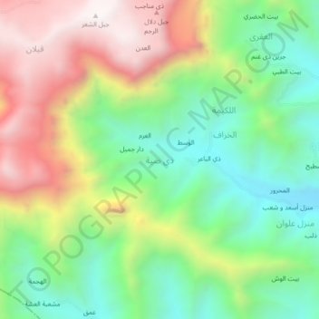
Name: Dha Sayyah topographic map, elevation, terrain.
Location: Dha Sayyah, Ash Shair, Gouvernorat d'Ibb, Yémen (14.01151 44.33041 14.05151 44.37041)
Average elevation: 2,574 m
Minimum elevation: 2,138 m
Maximum elevation: 3,192 m
Other topographic maps
Click on a map to view its topography, its elevation and its terrain.
الطيني
الطيني, Dhi as Sufal, Gouvernorat d'Ibb, Yémen
Average elevation: 2,228 m
Yarim
Yémen > Gouvernorat d'Ibb > Yarim
Yarim, Qada Yarim, Gouvernorat d'Ibb, Yémen
Average elevation: 2,645 m
الغديرة
Yémen > Gouvernorat d'Ibb > Al Mahrur > الغديرة
الغديرة, Al Mahrur, Hazm al Udayn, Gouvernorat d'Ibb, Yémen
Average elevation: 1,441 m
Ar Raqqah
Yémen > Gouvernorat d'Ibb > Ar Raqqah
Ar Raqqah, Ash Shair, Gouvernorat d'Ibb, Yémen
Average elevation: 2,447 m
علاي
Yémen > Gouvernorat d'Ibb > علاي
علاي, Hubaysh, Gouvernorat d'Ibb, Yémen
Average elevation: 2,323 m