
Make a donation
Gear up for your next adventure:
As an Amazon Associate, this site earns from qualifying purchases at no extra cost to you.
Kendu Bay topographic map
Click on the map to display elevation.
Make a donation
Gear up for your next adventure:
As an Amazon Associate, this site earns from qualifying purchases at no extra cost to you.
About this map
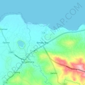
Name: Kendu Bay topographic map, elevation, terrain.
Location: Kendu Bay, Homa Bay County, Nyanza, Kenya (-0.40660 34.61000 -0.32660 34.69000)
Average elevation: 1,168 m
Minimum elevation: 1,131 m
Maximum elevation: 1,338 m
Make a donation
Gear up for your next adventure:
As an Amazon Associate, this site earns from qualifying purchases at no extra cost to you.
Other topographic maps
Click on a map to view its topography, its elevation and its terrain.
Takawiri Island
Kenya > Homa Bay County > Mbita > Mfangano Island ward > Sena
Average elevation: 1,139 m
Make a donation
Gear up for your next adventure:
As an Amazon Associate, this site earns from qualifying purchases at no extra cost to you.
Takawiri Island
Kenya > Homa Bay County > Mbita > Mfangano Island ward > Sena
Average elevation: 1,139 m
Make a donation
Gear up for your next adventure:
As an Amazon Associate, this site earns from qualifying purchases at no extra cost to you.
Make a donation
Gear up for your next adventure:
As an Amazon Associate, this site earns from qualifying purchases at no extra cost to you.