Geolocate

Carapo topographic map

Click on the map to display elevation.

About this map

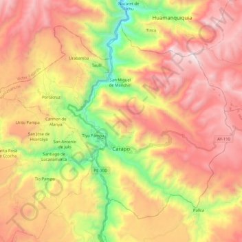
Name: Carapo topographic map, elevation, terrain.

Location: Carapo, Province of Huancasancos, Ayacucho, Peru (-13.89505 -74.42587 -13.73357 -74.22090)

Average elevation: 3,810 m

Minimum elevation: 2,768 m

Maximum elevation: 4,707 m

Other topographic maps

Click on a map to view its topography, its elevation and its terrain.

Villarica

Peru > Ayacucho > Río Magdalena > Paquichari

Average elevation: 1,041 m

Poma

Peru > Ayacucho > Querobamba

Average elevation: 3,482 m

La Vega

Peru > Ayacucho

Average elevation: 2,883 m

Province of Víctor Fajardo

Peru > Ayacucho

Average elevation: 3,598 m

Chantani

Peru > Ayacucho > Coracora

Average elevation: 3,110 m

Samana

Peru > Ayacucho > Socos

Average elevation: 3,561 m

Santa Fe

Peru > Ayacucho

Average elevation: 4,522 m

Chicha

Peru > Ayacucho > San Pedro de Larcay > Chicha

Average elevation: 3,540 m

Gear up for your next adventure:

🧷Tenacious Repair Tape - Instant fix for torn tents, jackets, or dry bags
Camping Shelters - Emergency and lightweight shelters for outdoor use
👟Waterproof Leg Gaiters - Keep mud and water out of your boots in boggy terrain
🧼Camping Hygiene Kits - Compact hygiene essentials for outdoor stays
🔥Emergency Fire Starters - Reliable ignition tools for survival situations in damp conditions

As an Amazon Associate, this site earns from qualifying purchases at no extra cost to you.