
Make a donation
Gear up for your next adventure:
As an Amazon Associate, this site earns from qualifying purchases at no extra cost to you.
Xaythany District topographic map
Click on the map to display elevation.
Make a donation
Gear up for your next adventure:
As an Amazon Associate, this site earns from qualifying purchases at no extra cost to you.
About this map
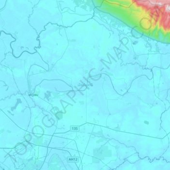
Name: Xaythany District topographic map, elevation, terrain.
Location: Xaythany District, Vientiane Prefecture, Laos (17.98725 102.55771 18.31053 102.89508)
Average elevation: 195 m
Minimum elevation: 160 m
Maximum elevation: 1,023 m
Make a donation
Gear up for your next adventure:
As an Amazon Associate, this site earns from qualifying purchases at no extra cost to you.
Other topographic maps
Click on a map to view its topography, its elevation and its terrain.
B. Haysok
Laos > Vientiane Prefecture > Chanthabuly District > Vientiane Capital
Average elevation: 170 m
Dongphosy
Laos > Vientiane Prefecture > Hadxayfong District > Vientiane Capital
Average elevation: 168 m
ທົ່ງປົງ
Laos > Vientiane Prefecture > Sikhottabong District > Vientiane Capital
Average elevation: 174 m
Make a donation
Gear up for your next adventure:
As an Amazon Associate, this site earns from qualifying purchases at no extra cost to you.
Phonsinouan
Laos > Vientiane Prefecture > Sisattanak District > Vientiane Capital
Average elevation: 170 m
Donnokkhoum
Laos > Vientiane Prefecture > Sisattanak District > Vientiane Capital
Average elevation: 170 m
Make a donation
Gear up for your next adventure:
As an Amazon Associate, this site earns from qualifying purchases at no extra cost to you.
Muangvatha
Laos > Vientiane Prefecture > Sikhottabong District > Vientiane Capital
Average elevation: 169 m
Chommanytai
Laos > Vientiane Prefecture > Xaysetha District > Vientiane Capital
Average elevation: 172 m
Don Koy
Laos > Vientiane Prefecture > Sisattanak District > Vientiane Capital
Average elevation: 169 m
Saphangmo
Laos > Vientiane Prefecture > Xaysetha District > Vientiane Capital
Average elevation: 170 m
Make a donation
Gear up for your next adventure:
As an Amazon Associate, this site earns from qualifying purchases at no extra cost to you.
Nongtaeng
Laos > Vientiane Prefecture > Sikhottabong District > Vientiane Capital
Average elevation: 174 m
Nonghai
Laos > Vientiane Prefecture > Hadxayfong District > Vientiane Capital
Average elevation: 172 m
Dognaxoyneua
Laos > Vientiane Prefecture > Sikhottabong District > Vientiane Capital
Average elevation: 169 m
Make a donation
Gear up for your next adventure:
As an Amazon Associate, this site earns from qualifying purchases at no extra cost to you.
Nongtha Marsh
Laos > Vientiane Prefecture > Chanthabuly District > Vientiane Capital > B. Nongthanua
Average elevation: 175 m
Dongkhamxang
Laos > Vientiane Prefecture > Hadxayfong District > Vientiane Capital
Average elevation: 172 m
Thatlouangkang
Laos > Vientiane Prefecture > Xaysetha District > Vientiane Capital
Average elevation: 170 m
Make a donation
Gear up for your next adventure:
As an Amazon Associate, this site earns from qualifying purchases at no extra cost to you.
Sibounheuang
Laos > Vientiane Prefecture > Chanthabuly District > Sibounheuang
Average elevation: 171 m