
Rockland topographic map
Interactive map
Click on the map to display elevation.
About this map
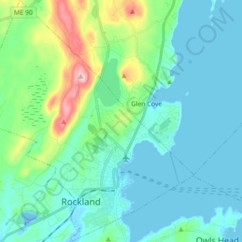
Name: Rockland topographic map, elevation, terrain.
Location: Rockland, Knox County, Maine, 04841, United States (44.08187 -69.18529 44.17260 -69.06950)
Average elevation: 45 m
Minimum elevation: -34 m
Maximum elevation: 197 m
Other topographic maps
Click on a map to view its topography, its elevation and its terrain.
Isle Au Haut
United States > Maine > Knox County > Isle au Haut
Mount Champlain, elevation 540 feet (160 m), is the highest point on the island, located on a north-south ridge occupying the island's center. Rocky Mountain, elevation 511 feet (156 m), and Sawyer Mountain, at 486 feet (148 m), are neighboring summits along the ridge to the south.[8] The terrain consists of…
Average elevation: 14 m
Camden
United States > Maine > Knox County
According to the U.S. Census Bureau, the town has a total area of 26.65 square miles (69.02 km2), of which, 18.24 square miles (47.24 km2) of it is land and 8.41 square miles (21.78 km2) is water. Drained by the Megunticook River, Camden is located beside Penobscot Bay and the Gulf of Maine, part of the…
Average elevation: 63 m
Union
United States > Maine > Knox County
According to the United States Census Bureau, the town has a total area of 34.49 square miles (89.33 km2), of which, 32.15 square miles (83.27 km2) of it is land and 2.34 square miles (6.06 km2) is water. Union is drained by the Medomak River, Saint George River, Pettengill Stream, Fuller Brook, Hope Brook,…
Average elevation: 89 m