Geolocate

Kiel topographic map

Click on the map to display elevation.

About this map

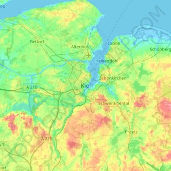
Name: Kiel topographic map, elevation, terrain.

Location: Kiel, Schleswig-Holstein, 24103, Germany (54.16271 9.97556 54.48271 10.29556)

Average elevation: 24 m

Minimum elevation: -4 m

Maximum elevation: 86 m

Other topographic maps

Click on a map to view its topography, its elevation and its terrain.

24149

Germany > Schleswig-Holstein > Kiel

Average elevation: 18 m

24105

Germany > Schleswig-Holstein > Kiel

Average elevation: 16 m

Gear up for your next adventure:

📦Dry Bags - Waterproof bags to protect gear from rain
🦶Anti-Blister Balms - Protect your feet before long topographic expeditions
📻Hand-Crank Emergency Radios - Stay updated on weather warnings in remote areas
🪓Outdoor Multitools - Versatile tools for hiking and camping
🛑Emergency Bivvy Bags - Heat-reflective survival bags for unexpected nights out

As an Amazon Associate, this site earns from qualifying purchases at no extra cost to you.