
Naturschutzgebiet Mönkeberger See topographic map
Interactive map
Click on the map to display elevation.
About this map
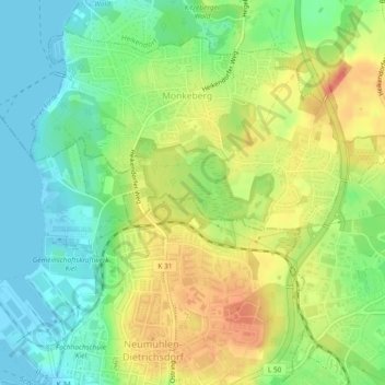
Name: Naturschutzgebiet Mönkeberger See topographic map, elevation, terrain.
Average elevation: 24 m
Minimum elevation: -1 m
Maximum elevation: 52 m
Other topographic maps
Click on a map to view its topography, its elevation and its terrain.
Kiel
Germany > Schleswig-Holstein > Kiel
Kiel, Schleswig-Holstein, 24103, Germany
Average elevation: 24 m