
Iririki topographic map
Interactive map
Click on the map to display elevation.
About this map
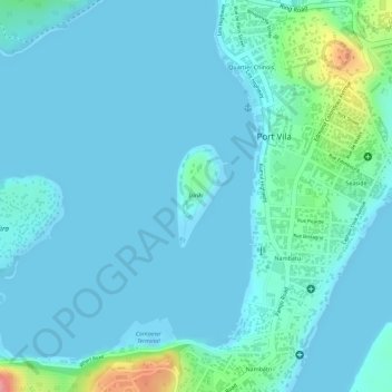
Name: Iririki topographic map, elevation, terrain.
Location: Iririki, Port Vila, Shefa Province, Vanuatu (-17.74914 168.30798 -17.74203 168.31157)
Average elevation: 16 m
Minimum elevation: -4 m
Maximum elevation: 115 m
Other topographic maps
Click on a map to view its topography, its elevation and its terrain.
Tongariki Island
Vanuatu > Shefa Province > Port Vila
Tongariki Island, Port Vila, Shefa Province, Vanuatu
Average elevation: 49 m
Emao
Vanuatu > Shefa Province > Port Vila
Emao, Port Vila, Shefa Province, Vanuatu
Average elevation: 96 m
Makura Island
Vanuatu > Shefa Province > Port Vila
Makura Island, Port Vila, Shefa Province, Vanuatu
Average elevation: 23 m
Nguna
Vanuatu > Shefa Province > Port Vila
Nguna, Port Vila, Shefa Province, Vanuatu
Average elevation: 75 m
Emae Island
Vanuatu > Shefa Province > Port Vila
Emae Island, Port Vila, Shefa Province, Vanuatu
Average elevation: 33 m