
Tongariki Island topographic map
Interactive map
Click on the map to display elevation.
About this map
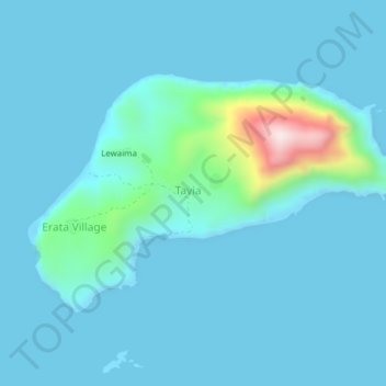
Name: Tongariki Island topographic map, elevation, terrain.
Location: Tongariki Island, Port Vila, Shefa Province, Vanuatu (-17.01776 168.61046 -16.99491 168.64902)
Average elevation: 49 m
Minimum elevation: -7 m
Maximum elevation: 511 m
Tongariki is a small island of volcanic origin located in the eastern Shepherd Islands, having no beaches or reefs. Several small islands lie close to the south coast. The island is 3.8 km long and 1.7 km wide. The estimated terrain elevation above the sea level is some 20 metres. The uninhabited island of Falea lies 1.8 km north-west of Tongariki.
Other topographic maps
Click on a map to view its topography, its elevation and its terrain.
Iririki
Vanuatu > Shefa Province > Port Vila
Iririki, Port Vila, Shefa Province, Vanuatu
Average elevation: 16 m
Emao
Vanuatu > Shefa Province > Port Vila
Emao, Port Vila, Shefa Province, Vanuatu
Average elevation: 96 m
Makura Island
Vanuatu > Shefa Province > Port Vila
Makura Island, Port Vila, Shefa Province, Vanuatu
Average elevation: 23 m
Nguna
Vanuatu > Shefa Province > Port Vila
Nguna, Port Vila, Shefa Province, Vanuatu
Average elevation: 75 m
Emae Island
Vanuatu > Shefa Province > Port Vila
Emae Island, Port Vila, Shefa Province, Vanuatu
Average elevation: 33 m