
Periyar National Park Tiger Reserve topographic map
Interactive map
Click on the map to display elevation.
Periyar National Park Tiger Reserve
Periyar National Park lies in the middle of a mountainous area of the Cardamom Hills. In the north, the boundary commences from the point nearest to the Medaganam in the interstate boundary up to Vellimalai. To the east the boundary follows the inter-state boundary from Vellimalai to Kallimalai Peak (1615 m) it is bounded by mountain ridges of over 1,700 m (5,600 ft) altitude. Toward the west it expands into a 1,200 m (3,900 ft) high plateau. From this level the altitude drops steeply to the deepest point of the reserve, the 100 metre valley of the Pamba River. The highest peak in the park is the 2,019 m (6,624 ft) high Kottamala, the southernmost peak in India higher than 2,000 metres (6,562 ft). The Periyar and Pamba Rivers originate in the forests of the reserve, both in Mlappara. The other prominent peaks within the park are Pachayarmala, Vellimala, Sunderamala, Chokkampetti mala and Karimala. The topography consists of steep and rolling hills which are thickly wooded.
About this map
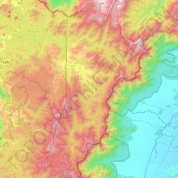
Name: Periyar National Park Tiger Reserve topographic map, elevation, terrain.
Average elevation: 929 m
Minimum elevation: 152 m
Maximum elevation: 1,971 m
Other topographic maps
Click on a map to view its topography, its elevation and its terrain.