Basin topographic map
Click on the map to display elevation.
About this map
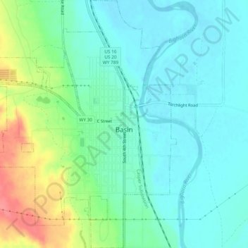
Name: Basin topographic map, elevation, terrain.
Location: Basin, Big Horn County, Wyoming, 82410, United States (44.36395 -108.06835 44.39745 -108.02908)
Average elevation: 1,188 m
Minimum elevation: 1,166 m
Maximum elevation: 1,244 m
Other topographic maps
Click on a map to view its topography, its elevation and its terrain.
Cloud Peak
United States > Wyoming > Big Horn County
Located in the 189,000-acre (765 km2) Cloud Peak Wilderness within Bighorn National Forest, the peak rises to an elevation of 13,171 feet (4,015 m). It can be climbed most easily from the western side, accessed by either the Battle Park or West Tensleep trailheads, which both form 24-mile (39 km) round trips…
Average elevation: 3,598 m
Cloud Peak
United States > Wyoming > Big Horn County
It rises to an elevation of 13,171 feet (4,015 m) and provides onlookers with dramatic views and vistas. The mountain can be climbed most easily from the western side, accessed by either the Battle Park or West Tensleep trail-heads and is roughly 24 miles round-trip from both. The peak is located in the…
Average elevation: 3,598 m