Geolocate

Priddis topographic map

Click on the map to display elevation.

Priddis

Priddis is a hamlet in Alberta, Canada within Foothills County. It is located in the foothills of the Canadian Rockies at an elevation of 1,160 metres (3,810 ft). The hamlet is located southwest of the intersection of the Cowboy Trail (Highway 22) and Highway 22X, approximately 10 kilometres (6.2 mi) west of Calgary's city limits.

Wikipedia (CC-BY-SA 3.0)

About this map

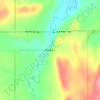
Name: Priddis topographic map, elevation, terrain.

Location: Priddis, Foothills County, Alberta, Canada (50.86479 -114.34574 50.90479 -114.30574)

Average elevation: 1,193 m

Minimum elevation: 1,146 m

Maximum elevation: 1,262 m

Other topographic maps

Click on a map to view its topography, its elevation and its terrain.

Sheep River

Canada > Alberta > Foothills County

Average elevation: 1,426 m

Highwood River

Canada > Alberta > Foothills County

Average elevation: 1,406 m

Sheep River

Canada > Alberta > Foothills County

Average elevation: 1,358 m

Gear up for your next adventure:

🕶️Polarized Sunglasses - Reduces glare from snow and water when reading terrain
🧺Microfibre Travel Towels - Fast-drying and compact towels for wild swimming and camping
🔥Emergency Fire Starters - Reliable ignition tools for survival situations in damp conditions
🧢Hiking Hats - Sun and weather protection for outdoor walks
🎒Backpack Rain Covers - Universal waterproof covers to protect your gear from downpours

As an Amazon Associate, this site earns from qualifying purchases at no extra cost to you.