
Make a donation
Gear up for your next adventure:
As an Amazon Associate, this site earns from qualifying purchases at no extra cost to you.
Sheep River topographic map
Click on the map to display elevation.
Make a donation
Gear up for your next adventure:
As an Amazon Associate, this site earns from qualifying purchases at no extra cost to you.
About this map
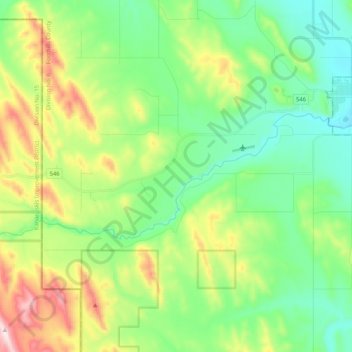
Name: Sheep River topographic map, elevation, terrain.
Location: Sheep River, Foothills County, Alberta, T0L 2O0, Canada (50.62001 -114.50000 50.66724 -114.29045)
Average elevation: 1,358 m
Minimum elevation: 1,204 m
Maximum elevation: 1,699 m
Make a donation
Gear up for your next adventure:
As an Amazon Associate, this site earns from qualifying purchases at no extra cost to you.
Other topographic maps
Click on a map to view its topography, its elevation and its terrain.
Priddis
Canada > Alberta > Foothills County
Priddis is a hamlet in Alberta, Canada within Foothills County. It is located in the foothills of the Canadian Rockies at an elevation of 1,160 metres (3,810 ft). The hamlet is located southwest of the intersection of the Cowboy Trail (Highway 22) and Highway 22X, approximately 10 kilometres (6.2 mi) west of…
Average elevation: 1,193 m
Make a donation
Gear up for your next adventure:
As an Amazon Associate, this site earns from qualifying purchases at no extra cost to you.