
City of Sarajevo topographic map
Interactive map
Click on the map to display elevation.
About this map
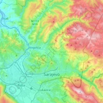
Name: City of Sarajevo topographic map, elevation, terrain.
Average elevation: 810 m
Minimum elevation: 437 m
Maximum elevation: 1,604 m
Other topographic maps
Click on a map to view its topography, its elevation and its terrain.
Janjići
Bosnia and Herzegovina > Federation of Bosnia and Herzegovina > City of Zenica
Average elevation: 519 m
Tvrtkovac
Bosnia and Herzegovina > Federation of Bosnia and Herzegovina > City of Zenica
Average elevation: 1,034 m
Bulčići
Bosnia and Herzegovina > Federation of Bosnia and Herzegovina > Grad Visoko
Average elevation: 629 m
Vranduk
Bosnia and Herzegovina > Federation of Bosnia and Herzegovina > City of Zenica
Average elevation: 533 m
Goduša
Bosnia and Herzegovina > Federation of Bosnia and Herzegovina > Grad Visoko
Average elevation: 681 m
Drvar
Bosnia and Herzegovina > Federation of Bosnia and Herzegovina
This extremely hilly region comprising the town of Drvar and the numerous outlying villages covers approximately 1,030 square kilometers (400 square miles). The town itself is mainly spread out from the left side of the river Unac, and its elevation is approximately 480 meters (1,574 feet).
Average elevation: 692 m
Sveti Grgur
Bosnia and Herzegovina > Federation of Bosnia and Herzegovina > City of Livno
Average elevation: 1,023 m
Ruište
Bosnia and Herzegovina > Federation of Bosnia and Herzegovina > City of Mostar
Average elevation: 1,125 m
Prenj
Bosnia and Herzegovina > Federation of Bosnia and Herzegovina > Town of Stolac
Average elevation: 188 m
Križevac
Bosnia and Herzegovina > Federation of Bosnia and Herzegovina > Town of Stolac > Stolac
Average elevation: 165 m
Vareš
Bosnia and Herzegovina > Federation of Bosnia and Herzegovina
The Vareš region also has possibilities for winter tourism development. Due to its position and elevation snow stays longer than in other regions, and the beautiful areas surrounding it are really good for skiing and skating. The mountain resort Doli is located on Zvijezda Mountain.
Average elevation: 1,091 m
Dobrnja
Bosnia and Herzegovina > Federation of Bosnia and Herzegovina > City of Tuzla
Average elevation: 289 m
Vitorog
Bosnia and Herzegovina > Federation of Bosnia and Herzegovina > Brnjići
Average elevation: 1,256 m
Kulen Vakuf
Bosnia and Herzegovina > Federation of Bosnia and Herzegovina > City of Bihać
Average elevation: 460 m
Lukavac
Bosnia and Herzegovina > Federation of Bosnia and Herzegovina > Town of Lukavac
Average elevation: 222 m
Posušje
Bosnia and Herzegovina > Federation of Bosnia and Herzegovina
Posušje field is located at an altitude of about 610 m, Vir field at about 520 m, Rakitno at about 900 m, Pločno (peak of Čvrsnica mountain) is at 2228 m, and the area around the lake Blidinje 1050 meters and more.
Average elevation: 752 m
Sarajevo
Bosnia and Herzegovina > Federation of Bosnia and Herzegovina > Sarajevo
Average elevation: 950 m
Livno
Bosnia and Herzegovina > Federation of Bosnia and Herzegovina > City of Livno
Average elevation: 907 m
Dobro
Bosnia and Herzegovina > Federation of Bosnia and Herzegovina > Grad Visoko
Average elevation: 565 m
Lisovo
Bosnia and Herzegovina > Federation of Bosnia and Herzegovina > Grad Visoko
Average elevation: 579 m
Mostar
Bosnia and Herzegovina > Federation of Bosnia and Herzegovina > City of Mostar
Average elevation: 602 m
Prokoško jezero
Bosnia and Herzegovina > Federation of Bosnia and Herzegovina
Average elevation: 1,723 m
Novi Šeher
Bosnia and Herzegovina > Federation of Bosnia and Herzegovina > Novi Šeher
Average elevation: 276 m
Čapljina
Bosnia and Herzegovina > Federation of Bosnia and Herzegovina > Čapljina
Average elevation: 98 m
Dolovi
Bosnia and Herzegovina > Federation of Bosnia and Herzegovina > Dolovi
Average elevation: 516 m
Bradina
Bosnia and Herzegovina > Federation of Bosnia and Herzegovina > Bradina
Average elevation: 958 m
Stolac
Bosnia and Herzegovina > Federation of Bosnia and Herzegovina > Town of Stolac
Average elevation: 290 m
Bakovići
Bosnia and Herzegovina > Federation of Bosnia and Herzegovina > Bakovići
Average elevation: 839 m
Lom
Bosnia and Herzegovina > Federation of Bosnia and Herzegovina > Stari Teočak
Average elevation: 501 m
Dubrovnik
Bosnia and Herzegovina > Federation of Bosnia and Herzegovina > Kamenica
Average elevation: 845 m
Skakavac
Bosnia and Herzegovina > Federation of Bosnia and Herzegovina > City of Sarajevo
Average elevation: 1,114 m
Homolj
Bosnia and Herzegovina > Federation of Bosnia and Herzegovina > Homolj
Average elevation: 636 m
Zavidovići
Bosnia and Herzegovina > Federation of Bosnia and Herzegovina > Town of Zavidovići > Zavidovići
Average elevation: 330 m