
Here topographic map
Click on the map to display elevation.
About this map
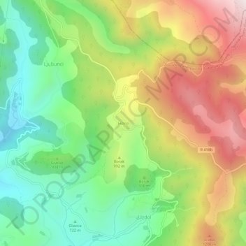
Name: Here topographic map, elevation, terrain.
Average elevation: 945 m
Minimum elevation: 577 m
Maximum elevation: 1,445 m
Other topographic maps
Click on a map to view its topography, its elevation and its terrain.
Prozor-Rama municipality
Bosnia and Herzegovina > Federation of Bosnia and Herzegovina
Average elevation: 1,151 m
Neum municipality
Bosnia and Herzegovina > Federation of Bosnia and Herzegovina
Average elevation: 279 m
Novi Grad Municipality
Bosnia and Herzegovina > Federation of Bosnia and Herzegovina > City of Sarajevo
Average elevation: 576 m
Posušje Municipality
Bosnia and Herzegovina > Federation of Bosnia and Herzegovina
Average elevation: 868 m
Drežanka
Bosnia and Herzegovina > Federation of Bosnia and Herzegovina > City of Mostar > Donja Drežnica
Drežanka springs at the foot of one of Bosnia and Herzegovina's largest mountain, Čvrsnica. Its karst spring rich in water is called Mošćenica or Mošćenuša and is situated at an altitude of 485 m. Not far downstream from the spring there are three waterfalls with a height of 10 to 12 meters.
Average elevation: 1,038 m
Kopanice
Bosnia and Herzegovina > Federation of Bosnia and Herzegovina > Town of Orašje
Average elevation: 82 m
MZ "Mošćanica"
Bosnia and Herzegovina > Federation of Bosnia and Herzegovina > City of Sarajevo
Average elevation: 1,024 m
Foča Municipality (FBiH)
Bosnia and Herzegovina > Federation of Bosnia and Herzegovina
Average elevation: 997 m