
Make a donation
Gear up for your next adventure:
As an Amazon Associate, this site earns from qualifying purchases at no extra cost to you.
Drvar topographic map
Click on the map to display elevation.
Make a donation
Gear up for your next adventure:
As an Amazon Associate, this site earns from qualifying purchases at no extra cost to you.
Drvar
This extremely hilly region comprising the town of Drvar and the numerous outlying villages covers approximately 1,030 square kilometers (400 square miles). The town itself is mainly spread out from the left side of the river Unac, and its elevation is approximately 480 meters (1,574 feet).
Make a donation
Gear up for your next adventure:
As an Amazon Associate, this site earns from qualifying purchases at no extra cost to you.
About this map
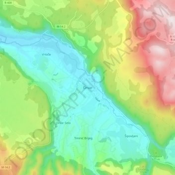
Name: Drvar topographic map, elevation, terrain.
Average elevation: 692 m
Minimum elevation: 446 m
Maximum elevation: 1,142 m
Make a donation
Gear up for your next adventure:
As an Amazon Associate, this site earns from qualifying purchases at no extra cost to you.
Other topographic maps
Click on a map to view its topography, its elevation and its terrain.
MZ "Mošćanica"
Bosnia and Herzegovina > Federation of Bosnia and Herzegovina > City of Sarajevo
Average elevation: 1,024 m
Prozor-Rama municipality
Bosnia and Herzegovina > Federation of Bosnia and Herzegovina
Average elevation: 1,151 m
Drežanka
Bosnia and Herzegovina > Federation of Bosnia and Herzegovina > City of Mostar > Donja Drežnica
Drežanka springs at the foot of one of Bosnia and Herzegovina's largest mountain, Čvrsnica. Its karst spring rich in water is called Mošćenica or Mošćenuša and is situated at an altitude of 485 m. Not far downstream from the spring there are three waterfalls with a height of 10 to 12 meters.
Average elevation: 1,038 m
Make a donation
Gear up for your next adventure:
As an Amazon Associate, this site earns from qualifying purchases at no extra cost to you.
Foča Municipality (FBiH)
Bosnia and Herzegovina > Federation of Bosnia and Herzegovina
Average elevation: 997 m
Kopanice
Bosnia and Herzegovina > Federation of Bosnia and Herzegovina > Town of Orašje
Average elevation: 82 m
Posušje Municipality
Bosnia and Herzegovina > Federation of Bosnia and Herzegovina
Average elevation: 868 m
Make a donation
Gear up for your next adventure:
As an Amazon Associate, this site earns from qualifying purchases at no extra cost to you.
Neum municipality
Bosnia and Herzegovina > Federation of Bosnia and Herzegovina
Average elevation: 279 m
Novi Grad Municipality
Bosnia and Herzegovina > Federation of Bosnia and Herzegovina > City of Sarajevo
Average elevation: 576 m
Prokoško jezero
Bosnia and Herzegovina > Federation of Bosnia and Herzegovina
Average elevation: 1,723 m
Make a donation
Gear up for your next adventure:
As an Amazon Associate, this site earns from qualifying purchases at no extra cost to you.