
Kalborn topographic map
Interactive map
Click on the map to display elevation.
About this map
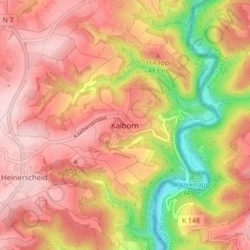
Name: Kalborn topographic map, elevation, terrain.
Location: Kalborn, Clervaux, Canton Clervaux, 9757, Luxemburg (50.08267 6.09216 50.12267 6.13216)
Average elevation: 447 m
Minimum elevation: 292 m
Maximum elevation: 539 m
Other topographic maps
Click on a map to view its topography, its elevation and its terrain.
Heinerscheid
Luxemburg > Canton Clervaux > Clervaux
Heinerscheid, Clervaux, Canton Clervaux, Luxemburg
Average elevation: 458 m