
Basak topographic map
Click on the map to display elevation.
Basak
Basak is situated in the south of Lapu-Lapu City, north of the Gabi River. It has an area of 8.007 square kilometers. It has an average elevation of 5 meters above sea level.
About this map
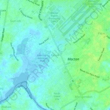
Name: Basak topographic map, elevation, terrain.
Location: Basak, Lapu-Lapu, Central Visayas, 6016, Philippines (10.26957 123.94552 10.30957 123.98552)
Average elevation: 5 m
Minimum elevation: -2 m
Maximum elevation: 11 m
Other topographic maps
Click on a map to view its topography, its elevation and its terrain.