
JPark Island Waterpark topographic map
Interactive map
Click on the map to display elevation.
About this map
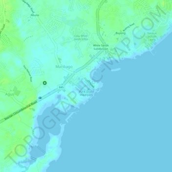
Name: JPark Island Waterpark topographic map, elevation, terrain.
Average elevation: 3 m
Minimum elevation: -3 m
Maximum elevation: 11 m
Other topographic maps
Click on a map to view its topography, its elevation and its terrain.
Basak
Basak, Lapu-Lapu, Central Visayas, 6016, Philippines
Average elevation: 5 m
Pusok
Philippines > Lapu-Lapu > Pusok
Pusok, Lapu-Lapu, Central Visayas, 6015, Philippines
Average elevation: 5 m
Maribago
Philippines > Lapu-Lapu > Maribago
Maribago, Lapu-Lapu, Central Visayas, 6015, Philippines
Average elevation: 5 m
Bankal
Philippines > Lapu-Lapu > Bankal
Bankal, Lapu-Lapu, Central Visayas, 6016, Philippines
Average elevation: 6 m
Mactan
Philippines > Lapu-Lapu > Mactan
Mactan, Lapu-Lapu, Central Visayas, 6015, Philippines
Average elevation: 5 m