
Hạ Long City topographic map
Interactive map
Click on the map to display elevation.
About this map
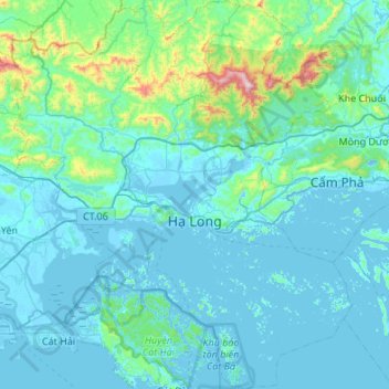
Name: Hạ Long City topographic map, elevation, terrain.
Location: Hạ Long City, Quang Ninh Province, 36000, Vietnam (20.73502 106.82556 21.23899 107.29897)
Average elevation: 97 m
Minimum elevation: -5 m
Maximum elevation: 1,035 m
Other topographic maps
Click on a map to view its topography, its elevation and its terrain.
Móng Cái City
Móng Cái City, Quảng Ninh Province, 02033, Vietnam
Average elevation: 19 m
Ha Long Bay Heritage Site
Vietnam > Quang Ninh Province > Vân Đồn District
Ha Long Bay Heritage Site, Vân Đồn District, Quảng Ninh Province, Vietnam
Average elevation: 9 m
Uông Bí
Vietnam > Quang Ninh Province > Uông Bí > Uông Bí
Uông Bí, Quang Ninh Province, 02306, Vietnam
Average elevation: 119 m
Ha Long
Vietnam > Quang Ninh Province > Ha Long
Ha Long, Hạ Long City, Quang Ninh Province, 36000, Vietnam
Average elevation: 55 m
Vân Đồn District
Vân Đồn District, Quang Ninh Province, 20000, Vietnam
Average elevation: 24 m