
Valcurta topographic map
Interactive map
Click on the map to display elevation.
About this map
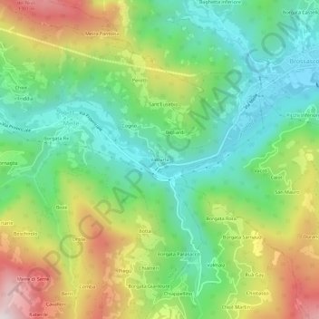
Name: Valcurta topographic map, elevation, terrain.
Location: Valcurta, Melle, Coni, Piémont, Italie (44.53748 7.31612 44.57748 7.35612)
Average elevation: 879 m
Minimum elevation: 588 m
Maximum elevation: 1,377 m
Other topographic maps
Click on a map to view its topography, its elevation and its terrain.
Borgata Re
Italie > Piémont > Coni > Melle
Borgata Re, Melle, Coni, Piémont, Italie
Average elevation: 920 m