
Salzwedel topographic map
Interactive map
Click on the map to display elevation.
About this map
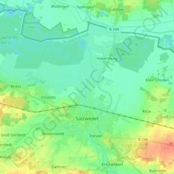
Name: Salzwedel topographic map, elevation, terrain.
Average elevation: 25 m
Minimum elevation: 12 m
Maximum elevation: 56 m
Other topographic maps
Click on a map to view its topography, its elevation and its terrain.
Milde
Germany > Saxony-Anhalt > Altmarkkreis Salzwedel
Milde, Altmarkkreis Salzwedel, Saxony-Anhalt, Germany
Average elevation: 59 m
Breitenfeld
Germany > Saxony-Anhalt > Altmarkkreis Salzwedel > Gardelegen
Breitenfeld, Gardelegen, Altmarkkreis Salzwedel, Saxony-Anhalt, Germany
Average elevation: 84 m
Gardelegen
Germany > Saxony-Anhalt > Altmarkkreis Salzwedel
Gardelegen, Altmarkkreis Salzwedel, Saxony-Anhalt, Germany
Average elevation: 68 m