
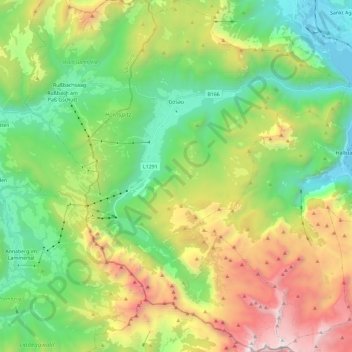
Gosau topographic map
Interactive map
Click on the map to display elevation.
About this map
Name: Gosau topographic map, elevation, terrain.
Location: Gosau, Bezirk Gmunden, Upper Austria, 4824, Austria (47.47303 13.47537 47.63038 13.65163)
Average elevation: 1,336 m
Minimum elevation: 502 m
Maximum elevation: 2,900 m
Gosau is situated along the Gosaubach stream in the Salzkammergut region. The center of the town is at an elevation of 767m (2,516'). 58.9% of the municipality is forested. At the southern end of Gosau there is a road leading to the Vorderer Gosausee, a lake with a view of the Dachstein.
Other topographic maps
Click on a map to view its topography, its elevation and its terrain.
Hallstatt
Austria > Upper Austria > Bezirk Gmunden
Hallstatt, Bezirk Gmunden, Upper Austria, 4830, Austria
Average elevation: 1,514 m
Scharnstein
Austria > Upper Austria > Bezirk Gmunden
Scharnstein, Bezirk Gmunden, Upper Austria, 4644, Austria
Average elevation: 689 m
Tauern
Austria > Upper Austria > Bezirk Gmunden > Bad Ischl
Tauern, Bad Ischl, Bezirk Gmunden, Upper Austria, 4820, Austria
Average elevation: 1,041 m
Winkl
Austria > Upper Austria > Bezirk Gmunden > Obertraun
Winkl, Obertraun, Bezirk Gmunden, Upper Austria, 4831, Austria
Average elevation: 829 m
Rosenkogel
Austria > Upper Austria > Bezirk Gmunden > Bad Ischl
Rosenkogel, Bad Ischl, Bezirk Gmunden, Upper Austria, 4820, Austria
Average elevation: 1,172 m
Krippenstein
Austria > Upper Austria > Bezirk Gmunden > Obertraun
Krippenstein, Obertraun, Bezirk Gmunden, Upper Austria, 4831, Austria
Average elevation: 1,728 m
Ramsau
Austria > Upper Austria > Bezirk Gmunden > Gosau
Ramsau, Gosau, Bezirk Gmunden, Upper Austria, 4824, Austria
Average elevation: 966 m
Sankt Konrad
Austria > Upper Austria > Bezirk Gmunden > Sankt Konrad
Sankt Konrad, Bezirk Gmunden, Upper Austria, 4817, Austria
Average elevation: 734 m
Bad Goisern
Austria > Upper Austria > Bezirk Gmunden > Bad Goisern am Hallstättersee > Bad Goisern
Bad Goisern, Bad Goisern am Hallstättersee, Bezirk Gmunden, Upper Austria, 4822, Austria
Average elevation: 644 m
Loser
Austria > Upper Austria > Bezirk Gmunden > Ebensee
Loser, Ebensee, Bezirk Gmunden, Upper Austria, 4802, Austria
Average elevation: 709 m
Obertraun
Austria > Upper Austria > Bezirk Gmunden
Obertraun, Bezirk Gmunden, Upper Austria, 4831, Austria
Average elevation: 1,629 m
Gmunden
Austria > Upper Austria > Bezirk Gmunden
Gmunden, Bezirk Gmunden, Upper Austria, 4810, Austria
Average elevation: 692 m