Geolocate

Caticlan topographic map

Click on the map to display elevation.

About this map
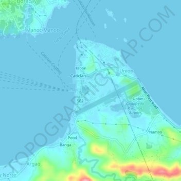
Name: Caticlan topographic map, elevation, terrain.

Location: Caticlan, Malay, Aklan, Western Visayas, 5608, Philippines (11.91048 121.93114 11.95048 121.97114)

Average elevation: 8 m

Minimum elevation: -1 m

Maximum elevation: 95 m

Other topographic maps

Click on a map to view its topography, its elevation and its terrain.

Potol

Philippines > Aklan > Malay > Argao > Potol

Average elevation: 28 m

Boracay

Philippines > Aklan > Malay > Caticlan

Average elevation: 6 m

Punta Bunga Beach

Philippines > Aklan > Malay

Average elevation: 16 m

Ilig Iligan Beach

Philippines > Aklan > Malay

Average elevation: 13 m

Boracay

Philippines > Aklan > Malay > Caticlan

Average elevation: 6 m

Boracay

Philippines > Aklan > Malay > Caticlan

Average elevation: 6 m

Boracay

Philippines > Aklan > Malay

Average elevation: 6 m

Boracay

Philippines > Aklan > Malay > Caticlan

Average elevation: 6 m

Boracay

Philippines > Aklan > Malay

Average elevation: 6 m

Manoc-Manoc

Philippines > Aklan > Malay

Average elevation: 5 m

Gear up for your next adventure:

🧰Survival Kits - Emergency tools for remote environments
🧼Technical Clothing Wash - Special soap to clean and restore waterproof membranes
🧴Sport Sunscreen Sticks - High-protection sunblock that won't run into your eyes on the trail
🧤Waterproof Overmitts - Extreme weather protection for hikers and mountaineers
🌦️Portable Weather Meters - Handheld tools for monitoring weather conditions

As an Amazon Associate, this site earns from qualifying purchases at no extra cost to you.