
San Onofre topographic map
Interactive map
Click on the map to display elevation.
About this map
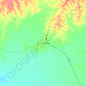
Name: San Onofre topographic map, elevation, terrain.
Location: San Onofre, Sucre, Colombia (9.69863 -75.56342 9.77863 -75.48342)
Average elevation: 32 m
Minimum elevation: 6 m
Maximum elevation: 83 m
Other topographic maps
Click on a map to view its topography, its elevation and its terrain.
Las Brisas
Colombia > Sucre > San Onofre
Las Brisas, San Onofre, Morrosquillo, Sucre, Colombia
Average elevation: 70 m
Corregimiento Higueron
Colombia > Sucre > San Onofre > Corregimiento Higueron
Corregimiento Higueron, San Onofre, Morrosquillo, Sucre, Colombia
Average elevation: 66 m