
Oybin topographic map
Interactive map
Click on the map to display elevation.
About this map
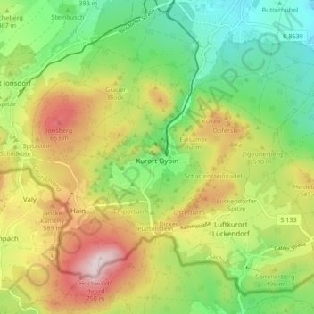
Name: Oybin topographic map, elevation, terrain.
Location: Oybin, Olbersdorf, Görlitz, Saxony, 02797, Germany (50.81924 14.70872 50.86615 14.79313)
Average elevation: 465 m
Minimum elevation: 278 m
Maximum elevation: 728 m
Other topographic maps
Click on a map to view its topography, its elevation and its terrain.
Bad Muskau - Mužakow
Bad Muskau - Mužakow, Bad Muskau, Görlitz, Saxony, Germany
Average elevation: 130 m
Schlauroth
Germany > Saxony > Görlitz > Görlitz
Schlauroth, Görlitz, Saxony, 02827, Germany
Average elevation: 240 m
Neusalza-Spremberg
Germany > Saxony > Görlitz > Neusalza-Spremberg > Sonneberg
Neusalza-Spremberg, Sonneberg, Neusalza-Spremberg, Görlitz, Saxony, 02742, Germany
Average elevation: 355 m
Bruder Klaus
Germany > Saxony > Görlitz > Jonsdorf
Bruder Klaus, Jonsdorf, Olbersdorf, Görlitz, Saxony, 02796, Germany
Average elevation: 523 m