
Make a donation
Gear up for your next adventure:
As an Amazon Associate, this site earns from qualifying purchases at no extra cost to you.
Perugia topographic map
Click on the map to display elevation.
Make a donation
Gear up for your next adventure:
As an Amazon Associate, this site earns from qualifying purchases at no extra cost to you.
Perugia
Though Perugia is located in the central part of Italy, the city experiences a humid subtropical climate (Köppen climate classification Cfa) similar to much of Northern Italy due to its inland location and the diverse, hilly topography of Umbria. Typically, summers are warm to hot and humid, while winters are cold with occasional snowfall. The climate in this area has mild differences between highs and lows, with adequate rainfall year-round.
Make a donation
Gear up for your next adventure:
As an Amazon Associate, this site earns from qualifying purchases at no extra cost to you.
About this map
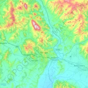
Name: Perugia topographic map, elevation, terrain.
Location: Perugia, Umbria, Italy (42.99345 12.17312 43.28607 12.56502)
Average elevation: 338 m
Minimum elevation: 165 m
Maximum elevation: 954 m
Make a donation
Gear up for your next adventure:
As an Amazon Associate, this site earns from qualifying purchases at no extra cost to you.
Other topographic maps
Click on a map to view its topography, its elevation and its terrain.
Make a donation
Gear up for your next adventure:
As an Amazon Associate, this site earns from qualifying purchases at no extra cost to you.
Vaiano
Italy > Umbria > Perugia > Castiglione del Lago
Vaiano is a frazione of the comune of Castiglione del Lago in the Province of Perugia, Umbria, central Italy. It stands at an elevation of 371 metres above sea level. At the time of the Istat census of 2001 it had 234 inhabitants.
Average elevation: 306 m
Make a donation
Gear up for your next adventure:
As an Amazon Associate, this site earns from qualifying purchases at no extra cost to you.
Make a donation
Gear up for your next adventure:
As an Amazon Associate, this site earns from qualifying purchases at no extra cost to you.
Make a donation
Gear up for your next adventure:
As an Amazon Associate, this site earns from qualifying purchases at no extra cost to you.
Casalalta
Italy > Umbria > Perugia > Collazzone
Casalalta is a frazione of the comune of Collazzone in the Province of Perugia, Umbria, central Italy. It stands at an elevation of 325 metres above sea level. At the time of the Istat census of 2001 it had 60 inhabitants.
Average elevation: 273 m
Make a donation
Gear up for your next adventure:
As an Amazon Associate, this site earns from qualifying purchases at no extra cost to you.
Make a donation
Gear up for your next adventure:
As an Amazon Associate, this site earns from qualifying purchases at no extra cost to you.
Ponticelli
Ponticelli is a frazione of the comune of Città della Pieve in the Province of Perugia, Umbria, central Italy. It stands at an elevation of 249 metres above sea level. At the time of the Istat census of 2001 it had 610 inhabitants.
Average elevation: 275 m
Make a donation
Gear up for your next adventure:
As an Amazon Associate, this site earns from qualifying purchases at no extra cost to you.
San Leo Bastia
Italy > Umbria > Perugia > Città di Castello
San Leo Bastia is a frazione of the comune of Città di Castello in the Province of Perugia, Umbria, central Italy. It stands at an elevation of 320 metres above sea level. At the time of the Istat census of 2001 it had 213 inhabitants.
Average elevation: 404 m
Make a donation
Gear up for your next adventure:
As an Amazon Associate, this site earns from qualifying purchases at no extra cost to you.
Pettino
Italy > Umbria > Perugia > Campello sul Clitunno
It stands at an elevation of 1074 metres above sea level. At the time of the Istat census of 2001, it had only 74 inhabitants.
Average elevation: 1,141 m
Make a donation
Gear up for your next adventure:
As an Amazon Associate, this site earns from qualifying purchases at no extra cost to you.
Make a donation
Gear up for your next adventure:
As an Amazon Associate, this site earns from qualifying purchases at no extra cost to you.