
Make a donation
Gear up for your next adventure:
As an Amazon Associate, this site earns from qualifying purchases at no extra cost to you.
Castel Rigone topographic map
Click on the map to display elevation.
Make a donation
Gear up for your next adventure:
As an Amazon Associate, this site earns from qualifying purchases at no extra cost to you.
About this map
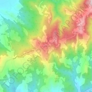
Name: Castel Rigone topographic map, elevation, terrain.
Average elevation: 478 m
Minimum elevation: 294 m
Maximum elevation: 738 m
Make a donation
Gear up for your next adventure:
As an Amazon Associate, this site earns from qualifying purchases at no extra cost to you.
Other topographic maps
Click on a map to view its topography, its elevation and its terrain.
Costacciaro
The town is situated on a hill at the foot of Mount Cucco, at an elevation of about 500 metres above sea level. It lies approximately 12 kilometres (7.5 mi) east of Gubbio and 18 kilometres (11 mi) west of Fabriano.
Average elevation: 695 m
Perugia
Though Perugia is located in the central part of Italy, the city experiences a humid subtropical climate (Köppen climate classification Cfa) similar to much of Northern Italy due to its inland location and the diverse, hilly topography of Umbria. Typically, summers are warm to hot and humid, while winters are…
Average elevation: 338 m
Make a donation
Gear up for your next adventure:
As an Amazon Associate, this site earns from qualifying purchases at no extra cost to you.
Make a donation
Gear up for your next adventure:
As an Amazon Associate, this site earns from qualifying purchases at no extra cost to you.
Make a donation
Gear up for your next adventure:
As an Amazon Associate, this site earns from qualifying purchases at no extra cost to you.
Trevi
The natural environment of the territory as a whole remains largely unspoiled, this despite being significantly populated for millennia. The mountainous area is now witnessing a considerable depopulation — as elsewhere in Italy, in the second half of the 20th century settlements at the highest elevations…
Average elevation: 507 m
Perugia
Though Perugia is located in the central part of Italy, the city experiences a humid subtropical climate (Köppen climate classification Cfa) similar to much of Northern Italy due to its inland location and the diverse, hilly topography of Umbria. Typically, summers are warm to hot and humid, while winters are…
Average elevation: 338 m
Make a donation
Gear up for your next adventure:
As an Amazon Associate, this site earns from qualifying purchases at no extra cost to you.
Bastia Umbra
Bastia is situated in the Umbrian Valley [it] at a modest elevation. It stands in an open plain, with the horizon only limited to the east by Monte Subasio at a distance of 4 miles (6.4 km).
Average elevation: 203 m
Make a donation
Gear up for your next adventure:
As an Amazon Associate, this site earns from qualifying purchases at no extra cost to you.
Trevi
The natural environment of the territory as a whole remains largely unspoiled, this despite being significantly populated for millennia. The mountainous area is now witnessing a considerable depopulation — as elsewhere in Italy, in the second half of the 20th century settlements at the highest elevations…
Average elevation: 507 m
Make a donation
Gear up for your next adventure:
As an Amazon Associate, this site earns from qualifying purchases at no extra cost to you.
Make a donation
Gear up for your next adventure:
As an Amazon Associate, this site earns from qualifying purchases at no extra cost to you.
Trevi
The natural environment of the territory as a whole remains largely unspoiled, this despite being significantly populated for millennia. The mountainous area is now witnessing a considerable depopulation — as elsewhere in Italy, in the second half of the 20th century settlements at the highest elevations…
Average elevation: 507 m