
Krupanj topographic map
Interactive map
Click on the map to display elevation.
About this map
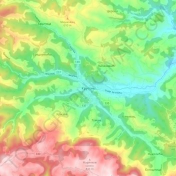
Name: Krupanj topographic map, elevation, terrain.
Average elevation: 484 m
Minimum elevation: 229 m
Maximum elevation: 876 m
The town lies in western Serbia, at the southern border of the Pannonian plain and Mačva region. It is surrounded by the mountains Jagodnja, Boranja and Sokolska planina, in a valley intersected by several rivers and creeks. In the town itself, the rivers Bogoštica, Čađavica and Kržava conjoin into Likodra, which later empties into Jadar. The town lies at the altitude of 280 m.
Other topographic maps
Click on a map to view its topography, its elevation and its terrain.
Brezovice
Serbia > Central Serbia > Macva Administrative District > Krupanj Municipality
Brezovice, Krupanj Municipality, Macva Administrative District, Central Serbia, 15312, Serbia
Average elevation: 240 m