
Kasungu topographic map
Interactive map
Click on the map to display elevation.
About this map
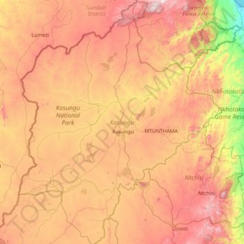
Name: Kasungu topographic map, elevation, terrain.
Location: Kasungu, Central Region, Malawi (-13.62043 32.92652 -12.36393 34.00346)
Average elevation: 1,086 m
Minimum elevation: 474 m
Maximum elevation: 1,813 m
Other topographic maps
Click on a map to view its topography, its elevation and its terrain.
Kasungu National Park
Kasungu National Park, Kasungu, Central Region, Malawi, Malawi
Average elevation: 1,087 m