
Make a donation
Gear up for your next adventure:
As an Amazon Associate, this site earns from qualifying purchases at no extra cost to you.
Porter topographic map
Click on the map to display elevation.
Make a donation
Gear up for your next adventure:
As an Amazon Associate, this site earns from qualifying purchases at no extra cost to you.
About this map
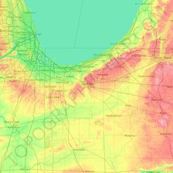
Name: Porter topographic map, elevation, terrain.
Location: Porter, Indiana, 46385, United States (40.74570 -87.77250 42.14570 -86.37250)
Average elevation: 207 m
Minimum elevation: 171 m
Maximum elevation: 286 m
Make a donation
Gear up for your next adventure:
As an Amazon Associate, this site earns from qualifying purchases at no extra cost to you.
Other topographic maps
Click on a map to view its topography, its elevation and its terrain.
Fort Wayne
United States > Indiana > Allen County
The first settlement started in 1815. In 1819, the military garrison abandoned the fort and moved to Detroit. In 1822, a federal land office opened to sell land ceded by local Native Americans by the Treaty of St. Mary's in 1818. Platted in 1823 at the Ewing Tavern, the village became an important frontier…
Average elevation: 246 m
Bloomington
United States > Indiana > Monroe County
Bloomington is an area of irregular limestone terrain characterized by sinks, ravines, fissures, underground streams, sinking streams, springs and caves. It is in the rolling hills of southern Indiana, resting on the intersection of the Norman Uplands and the Mitchell Plain. The city's relatively varied…
Average elevation: 241 m
Make a donation
Gear up for your next adventure:
As an Amazon Associate, this site earns from qualifying purchases at no extra cost to you.
West Lafayette
United States > Indiana > Tippecanoe County
West Lafayette, located in Tippecanoe County, Indiana, presents a varied topography, particularly shaped by its proximity to the Wabash River. The city spans an elevation range from approximately 500 feet near the river to over 720 feet in its northern sections, offering a noticeable incline toward higher…
Average elevation: 192 m
South Bend
United States > Indiana > Saint Joseph County
On September 29, 1929, South Bend completed its "track elevation program". This was a railroad infrastructure project which saw the removal of Grand Trunk Western Railroad tracks from Division Street, the removal of level crossings from Chapin to Miami streets, the creation of a modern freight layout, and the…
Average elevation: 236 m
Make a donation
Gear up for your next adventure:
As an Amazon Associate, this site earns from qualifying purchases at no extra cost to you.
Morgan County
Morgan County is where the glaciers stopped their southward advance during the last ice age. As a result, the area has both flat areas and rolling hills, with the most diverse soil of any county in the United States. The extensive woodlands of the eighteenth century have been cleared on the county's flat…
Average elevation: 224 m
Make a donation
Gear up for your next adventure:
As an Amazon Associate, this site earns from qualifying purchases at no extra cost to you.
Make a donation
Gear up for your next adventure:
As an Amazon Associate, this site earns from qualifying purchases at no extra cost to you.
Make a donation
Gear up for your next adventure:
As an Amazon Associate, this site earns from qualifying purchases at no extra cost to you.
Make a donation
Gear up for your next adventure:
As an Amazon Associate, this site earns from qualifying purchases at no extra cost to you.
Fountain County
According to the 2010 United States Census, the county has a total area of 397.88 square miles (1,030.5 km2), of which 395.66 square miles (1,024.8 km2) (or 99.44%) is land and 2.22 square miles (5.7 km2) (or 0.56%) is water. Elevations range from 770 feet (230 m) above sea level in the northeastern part of…
Average elevation: 206 m
Make a donation
Gear up for your next adventure:
As an Amazon Associate, this site earns from qualifying purchases at no extra cost to you.
Make a donation
Gear up for your next adventure:
As an Amazon Associate, this site earns from qualifying purchases at no extra cost to you.
Make a donation
Gear up for your next adventure:
As an Amazon Associate, this site earns from qualifying purchases at no extra cost to you.
Tipton County
The present courthouse was designed by Adolph Sherrer. He had taken over the Indiana Statehouse project when architect Edwin May died in 1880; five years after the completion of that project in 1888, Scherrer began work on the Tipton building, which was built of sandstone in a Romanesque style with a clock…
Average elevation: 267 m
Make a donation
Gear up for your next adventure:
As an Amazon Associate, this site earns from qualifying purchases at no extra cost to you.
Make a donation
Gear up for your next adventure:
As an Amazon Associate, this site earns from qualifying purchases at no extra cost to you.
Benton County
Benton County lies along the state's western border with Illinois. It consists of low rolling hills, with all available terrain devoted to agriculture or development. Data gathered from space shuttle measurements list the county's lowest elevation as 138 meters (453 feet) and its highest elevation as 240…
Average elevation: 230 m
Make a donation
Gear up for your next adventure:
As an Amazon Associate, this site earns from qualifying purchases at no extra cost to you.
Warren County
According to the 2010 census, the county has a total area of 366.40 square miles (949.0 km2), of which 364.68 square miles (944.5 km2) (or 99.53%) is land and 1.72 square miles (4.5 km2) (or 0.47%) is water. Elevations in the county range from 480 feet (150 m) above sea level where the Wabash River enters…
Average elevation: 208 m
Make a donation
Gear up for your next adventure:
As an Amazon Associate, this site earns from qualifying purchases at no extra cost to you.
Lake County
The central part of the county is higher and hillier. As you travel south from the low and relatively flat lake plain in the northern part of the county, the land gradually rises in elevation until the peak of the Valparaiso Moraine. The highest point, at 801 feet (244 m), is in northeastern Winfield Township…
Average elevation: 202 m
Floyd County
The Knobs Unit, which includes Floyd County, contains some of the hilliest country in Indiana. As a result, the area supports trees that prefer very dry sites and ridgetops, as well as those that prefer very wet sites, ravines, or “bottomland.” Tree types unique to the unit include blackjack oak and swamp…
Average elevation: 210 m
Make a donation
Gear up for your next adventure:
As an Amazon Associate, this site earns from qualifying purchases at no extra cost to you.
Make a donation
Gear up for your next adventure:
As an Amazon Associate, this site earns from qualifying purchases at no extra cost to you.
Make a donation
Gear up for your next adventure:
As an Amazon Associate, this site earns from qualifying purchases at no extra cost to you.
Make a donation
Gear up for your next adventure:
As an Amazon Associate, this site earns from qualifying purchases at no extra cost to you.
Make a donation
Gear up for your next adventure:
As an Amazon Associate, this site earns from qualifying purchases at no extra cost to you.
Make a donation
Gear up for your next adventure:
As an Amazon Associate, this site earns from qualifying purchases at no extra cost to you.
Make a donation
Gear up for your next adventure:
As an Amazon Associate, this site earns from qualifying purchases at no extra cost to you.
Lafayette
United States > Indiana > Tippecanoe County
Lafayette is located at 40°24′38″N 86°52′29″W / 40.410585°N 86.874681°W / 40.410585; -86.874681 (40.410585, −86.874681) and is located in Fairfield and Wea Townships. Elevation at the court house is 550 feet (168 m), but city elevations range from a little over 500 feet (150 m) at the…
Average elevation: 192 m
Make a donation
Gear up for your next adventure:
As an Amazon Associate, this site earns from qualifying purchases at no extra cost to you.
Porter County
Porter County lies on the northern edge of Indiana; its north border is formed by Lake Michigan and its south border is formed by the westward-flowing Kankakee River Its once-tree-covered low rolling hills have been cleared and devoted to agriculture; the only exceptions in Porter County are the drainages…
Average elevation: 207 m
Make a donation
Gear up for your next adventure:
As an Amazon Associate, this site earns from qualifying purchases at no extra cost to you.
Wayne County
According to the 2010 census, the county has a total area of 404.34 square miles (1,047.2 km2), of which 401.74 square miles (1,040.5 km2) (or 99.36%) is land and 2.60 square miles (6.7 km2) (or 0.64%) is water. Wayne County includes Indiana's highest natural elevation, Hoosier Hill, at 1,257 feet (383 m).
Average elevation: 322 m
Shelby County
The low, rolling hills of Shelby County are lightly carved by drainages, but are otherwise completely devoted to agriculture or urban development. The western edge of the county is drained by Sugar Creek, flowing south-southwestward into Johnson County. The central and SW parts of the county are drained by Big…
Average elevation: 241 m
Make a donation
Gear up for your next adventure:
As an Amazon Associate, this site earns from qualifying purchases at no extra cost to you.
Bloomington
United States > Indiana > Monroe County
Bloomington is an area of irregular limestone terrain characterized by sinks, ravines, fissures, underground streams, sinking streams, springs and caves. It is in the rolling hills of south Central Indiana, resting on the intersection of the Norman Upland and the Mitchell Plain. The city's relatively varied…
Average elevation: 241 m
Make a donation
Gear up for your next adventure:
As an Amazon Associate, this site earns from qualifying purchases at no extra cost to you.
South Bend
United States > Indiana > Saint Joseph County
On September 29, 1929, South Bend completed its "track elevation program". This was a railroad infrastructure project which saw the removal of Grand Trunk Western Railroad tracks from Division Street, the removal of level crossings from Chapin to Miami streets, the creation of a modern freight layout, and the…
Average elevation: 236 m
Make a donation
Gear up for your next adventure:
As an Amazon Associate, this site earns from qualifying purchases at no extra cost to you.