
Miesbach topographic map
Interactive map
Click on the map to display elevation.
Miesbach
Miesbach (German: [ˈmiːsˌbax] (listen)) is a town in Bavaria, Germany, and is the capital of the Miesbach district. The district is at an altitude of 697 metres above sea level. It covers an area of approximately 863.50 km² of alpine headlands and in 2017 had a population of 11,477. The town is located 48 km southeast of Munich. Lake Schliersee and Lake Tegernsee, around which are the internationally renowned spas, Bad Wiessee, Rottach-Egern and Tegernsee, are nearby. Miesbach was founded around the year 1000 and was for hundreds of years the seat of the County of Hohenwaldeck. In the 19th century it became the center of the conservation movement for the traditional costumes, the Tracht. Miesbach also has a rich history as a pilgrimage and a mining village, which can still be seen in the city landscape.
About this map
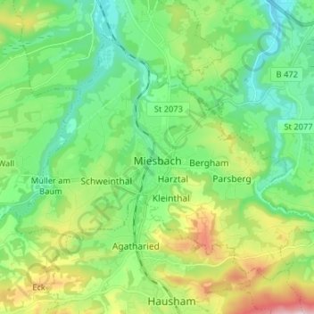
Name: Miesbach topographic map, elevation, terrain.
Location: Miesbach, Landkreis Miesbach, Bavaria, 83714, Germany (47.75656 11.77485 47.82548 11.90514)
Average elevation: 739 m
Minimum elevation: 606 m
Maximum elevation: 1,054 m
Other topographic maps
Click on a map to view its topography, its elevation and its terrain.