
Pommerloch topographic map
Interactive map
Click on the map to display elevation.
About this map
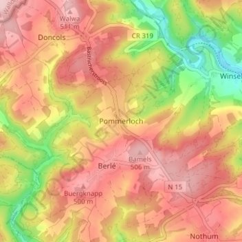
Name: Pommerloch topographic map, elevation, terrain.
Location: Pommerloch, Winseler, Canton Wiltz, 9638, Luxembourg (49.93953 5.84065 49.97953 5.88065)
Average elevation: 442 m
Minimum elevation: 325 m
Maximum elevation: 518 m
Other topographic maps
Click on a map to view its topography, its elevation and its terrain.
Pintsch
Luxembourg > Canton Wiltz > Kiischpelt
Pintsch, Kiischpelt, Canton Wiltz, 9767, Luxembourg
Average elevation: 376 m
Eschdorf
Eschdorf, Esch-sur-Sûre, Canton Wiltz, 9151, Luxembourg
Average elevation: 456 m
Watrange
Luxembourg > Canton Wiltz > Lac de la Haute-Sûre
Watrange, Lac de la Haute-Sûre, Canton Wiltz, 9690, Luxembourg
Average elevation: 468 m
Flebour
Flebour, Boulaide, Canton Wiltz, 9633, Luxembourg
Average elevation: 426 m
Berlé
Berlé, Winseler, Canton Wiltz, 9636, Luxembourg
Average elevation: 442 m
Esch-sur-Sûre
Esch-sur-Sûre, Canton Wiltz, Luxembourg
Average elevation: 425 m