Geolocate

Talihina topographic map

Click on the map to display elevation.

About this map
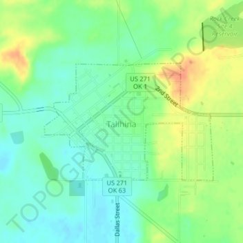
Name: Talihina topographic map, elevation, terrain.

Location: Talihina, LeFlore County, Oklahoma, United States (34.74613 -95.05234 34.75921 -95.02951)

Average elevation: 217 m

Minimum elevation: 201 m

Maximum elevation: 241 m

Other topographic maps

Click on a map to view its topography, its elevation and its terrain.
Cedar Knobb

United States > Oklahoma > LeFlore County > Pocola

Average elevation: 150 m

High Top

United States > Oklahoma > LeFlore County

Average elevation: 443 m

Leflore

United States > Oklahoma > LeFlore County > Le Flore

Average elevation: 175 m

Honobia

United States > Oklahoma > LeFlore County

Average elevation: 332 m

Hodgen

United States > Oklahoma > LeFlore County

Average elevation: 166 m

Buzzards Roost

United States > Oklahoma > LeFlore County

Average elevation: 163 m

Leflore

United States > Oklahoma > LeFlore County > Le Flore

Average elevation: 175 m

Goats Bluff

United States > Oklahoma > LeFlore County

Average elevation: 179 m

Page

United States > Oklahoma > LeFlore County

Average elevation: 388 m

Gear up for your next adventure:

🎒Replacement Sternum Straps - Repair parts for hiking rucksacks
🍲Portable Camping Stoves - Fast-boiling stoves for hot meals on remote topographic survey trips
🧴Tick Removal Tools - Small, essential health tool for UK woodland and moorland
🧤Hiking Gloves - Warm and durable gloves for cold-weather walks
🔋Rechargeable Batteries - Eco-friendly power for headlamps and older GPS units

As an Amazon Associate, this site earns from qualifying purchases at no extra cost to you.