
Saint Paul Island topographic map
Interactive map
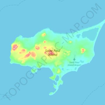
Click on the map to display elevation.
Saint Paul Island
Saint Paul is the largest of the Pribilof Islands and lies the farthest north. With a width of 7.66 mi (12.33 km) at its widest point and a length of 13.5 mi (21.7 km) on its longest axis (which runs from northeast to southwest), it has a total area of 43 sq mi (110 km2). Volcanic in origin, Saint Paul features a number of cinder cones and volcanic craters in its interior. The highest of these, Rush Hill, rises to 665 ft (203 m) on the island's western shore, though most of the upland areas average less than 150 ft (46 m) in elevation. Most of the island is a low-lying mix of rocky plateaus and valleys, with some of the valleys holding freshwater ponds. Much of its 45.5 mi (73.2 km) of shoreline is rugged and rocky, rising to sheer cliffs at several headlands, though long sandy beaches backed by shifting sand dunes flank a number of shallow bays.
About this map
Name: Saint Paul Island topographic map, elevation, terrain.
Average elevation: 10 m
Minimum elevation: 0 m
Maximum elevation: 192 m