Geolocate

Malla topographic map

Click on the map to display elevation.

About this map

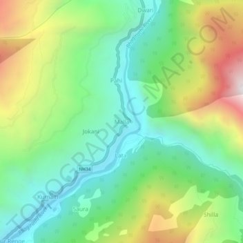
Name: Malla topographic map, elevation, terrain.

Location: Malla, Bhatwari, Uttarkashi, Uttarakhand, India (30.76644 78.59542 30.80644 78.63542)

Average elevation: 1,911 m

Minimum elevation: 1,414 m

Maximum elevation: 2,840 m

Other topographic maps

Click on a map to view its topography, its elevation and its terrain.

Kyarkoti Lake

India > Uttarakhand > Bhatwari

Average elevation: 4,043 m

Harsil

India > Uttarakhand > Bhatwari

Average elevation: 2,761 m

Pari Maatri Taal

India > Uttarakhand > Bhatwari

Average elevation: 4,443 m

Kedar Tal

India > Uttarakhand > Bhatwari

Average elevation: 4,814 m

Dayara Bugyal

India > Uttarakhand > Bhatwari

Average elevation: 3,451 m

Gangotri Glacier

India > Uttarakhand > Bhatwari

Average elevation: 5,259 m

Harsil

India > Uttarakhand > Bhatwari

Average elevation: 2,761 m

Kalindi Khal Area

India > Uttarakhand > Bhatwari

Average elevation: 5,857 m

Kedar Tal

India > Uttarakhand > Bhatwari

Average elevation: 4,814 m

Gangotri Glacier

India > Uttarakhand > Bhatwari

Average elevation: 5,259 m

Gear up for your next adventure:

🔋Solar Chargers - Eco-friendly charging solutions for outdoor use
📦Compression Sacks - Reduce backpack volume efficiently
🧺Microfibre Travel Towels - Fast-drying and compact towels for wild swimming and camping
👕Technical Hiking Tees - Moisture-management for high-exertion climbs
📦Dry Bags - Waterproof bags to protect gear from rain

As an Amazon Associate, this site earns from qualifying purchases at no extra cost to you.